
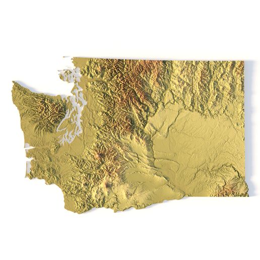

Washington Topographic Map – 3D Model for 3D Printing & CNC Carving

Download, slice and print this model in the MakerSpell app — available on Android and Windows. Get the app
Model Overview & Print Notes
Create Detailed Washington Terrain Models with This High-Resolution 3D STL The Washington Topographic Map STL model provides a high-resolution representation of the state's diverse geography, including the Cascade Range, Olympic Mountains, Puget Sound, and rolling hills of the eastern plains. This 3D model is ideal for crafting physical relief maps from wood, metal, plastic, or concrete. Perfect for landform visualization, educational projects, GIS applications, and professional terrain analysis, this model delivers accurate elevation data for detailed terrain modeling. Compatible with 3D printers, CNC machines, and laser engravers, it enables precise topographic reproduction. File size: 392 MB Model size: 145.8015 mm x 200 mm x 2.9987 mm Projection: Lambert conformal conic Scaling factor: X — 1; Y — 1; Z — 3 Polygons: 8 228 514 Vertices: 4 114 482 Geometry: Polygonal Tris only Base: Closed Features of the Washington Topographic STL Model ✔ Highly Detailed Elevation Data – Captures Washington’s mountainous regions, river valleys, and coastal topography. ✔ Optimized for 3D Printing – Compatible with FDM/SLA printers for precise terrain models. ✔ CNC Machining Ready – Ideal for crafting relief maps from wood, metal, or acrylic. ✔ Laser Engraving Support – Enables detailed surface etching on metal and other materials. Shustrik-Maps.com – Premium 3D Models for Terrain, Maps & Beyond High-Quality STL Files for 3D Printing & CNC ## 3D Printing Settings
💬Baskı İncelemeleri & Yorumlar(0)
★4.9 / 5.0· Başarılı Baskı